Explore Hole-in-the-Rock and the Mormon Trail
By Dave Webb
 In
November, 1879, a group of Mormon pioneers headed south out of Escalante
to colonize the San Juan Mission, now the town of Bluff. Rather than endure
a long, tedious journey around Glen Canyon, they decided to create a shortcut
across the canyon. Scouts identified a route and the group headed into
the desert. With incredible effort and ingenuity, they blazed what we
call the Hole-in-the-Rock trail.
In
November, 1879, a group of Mormon pioneers headed south out of Escalante
to colonize the San Juan Mission, now the town of Bluff. Rather than endure
a long, tedious journey around Glen Canyon, they decided to create a shortcut
across the canyon. Scouts identified a route and the group headed into
the desert. With incredible effort and ingenuity, they blazed what we
call the Hole-in-the-Rock trail.
The northern part of the trail is now a popular route for people seeking recreation in the Canyons of the Escalante area. It provides access to classic hikes in places like Coyote, 40-Mile and Spooky gulches.
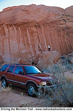
Just driving the trail is an adventure. From Highway 12 to the rim above Lake Powell, the trail is a moderately difficult 4X4 route, which plows through deep sand and climbs over rocky ridges. It is hard to imagine traveling the trail in a covered wagon, with a group consisting of 236 men, women and children, 200 horses and more than 1000 head of cattle.
Scouts had identified a crack in the cliff wall that allowed precarious access down into Glen Canyon and they determined to use it as a wagon road. They spent weeks blasting and shaping the rock and then lowered their wagons down the cliff.
One of the group, Elizabeth Morris Decker, gave this account in a letter to her parents: "If you ever come this way it will scare you to death to look down it. It is about a mile from the top down to the river and it is almost straight down, the cliffs on each side are five hundred ft. high and there is just room enough for a wagon to go down. It nearly scared me to death. The first wagon I saw go down they put the brake on and rough locked the hind wheels and had a big rope fastened to the wagon and about ten men holding back on it and then they went down like they would smash everything. I'll never forget that day. When we was walking down Willie looked back and cried and asked me how we would get back home."
 Today
youth groups travel to the top of the cliff in four-wheel-drive vehicles,
or to the bottom by boat, and marvel that the group survived the descent
without deadly mishap. There is no road. It's an almost vertical cliff
gouged with ruts from locked wagon wheels. A plaque has been set to honor
the pioneers.
Today
youth groups travel to the top of the cliff in four-wheel-drive vehicles,
or to the bottom by boat, and marvel that the group survived the descent
without deadly mishap. There is no road. It's an almost vertical cliff
gouged with ruts from locked wagon wheels. A plaque has been set to honor
the pioneers.
After fording the river the group proceeded up Cottonwood Canyon. The terrain here was also incredibly difficult. Decker described it as "...the roughest country you or anybody else ever seen; its nothing in the world but rocks and holes, hills and hollows. The mountains are just one solid rock as smooth as an apple." South and east of Lake Powell the route is called the Mormon Trail on most maps. It also provides access to incredible recreational spots but it is not heavily used because the area is so rough and remote.
As I searched for information a park ranger told me it was essentially impassible. Undaunted, I tried to drive it in my 4X4 Blazer but didn't make it very far. I stopped where the trail crossed a stream flowing through a quagmire of sand and sandstone. People on ATVs were working frantically to winch their machines across the stream. As they finished a Hummer came through and crossed without any difficulty. I've got to get one of those things!
Die-hard mountain bikers enjoy riding the Mormon Trail, although I suspect they end up pushing their bikes through some of the sand traps.
This is great country. You could spend a lifetime exploring here and never see it all. Exploring these routes will certainly give you more appreciation for the faith, determination and ingenuity of the pioneers. Below you will find technical information about the routes.
Update 10-10-06: copied your information on the Mormon Trail before we made the trip last week. We started from Hall's Crossing and got as far as the Chute above Cottonwood Canyon. We survived the "Storm of the Century" on Oct. 5th but were prevented from continuing down the Chute on the 6th due to rushing water from the storm. There was a 50 foot pool at the bottom. Upon returning, we were told that the trail back, at the head of Lake Canyon, was gone. That was the case. The trail is gone forever at that point. Our guide found an alternative route by climbing to where the trail ended and backtracking to our location. All and all it was a very exciting trip. - B Stewart
 Hole-in-the-Rock-Trail
Route Information (in miles) 0.0 Starting point
Finding the starting point
From Escalante, go east on Highway 12 for 3.6 miles, turn southeast
on the graded gravel road at the sign for Hole- in-the-Rock.
 Tips
and precautions
Tips
and precautions
Lowering the air pressure in your tires to about 17 PSI will make the
drive much more enjoyable on the washboard sections. Air back up in
Escalante or Boulder. There are no services at all, so be sure to have
a full tank of gas. This trip can be done in one long day, but two days
is preferable.
Mormon Trail
Get onto the trail from U-276 about 15 miles southeast of Halls Crossing.
We approached from U-95. If you pass the airport, you're too far west.
The West Turnoff is right on top of mile marker 59. The trail is easy
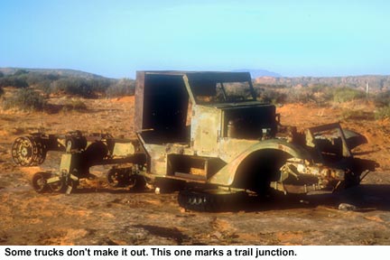
until you reach the fork in the road at the old truck about four miles
in. If you head to the left you will begin a steep ascent towards Nokai
Dome. That trail dies after 6 or 7 miles atop the summit, but affords
some awesome views and an exhilarating ride.
Continuing to the right will keep you on the Mormon Trail. After a few miles you will reach the edge of Lake Canyon, marked by the Fortress ruin, Where the already-rough trail becomes very challenging. The trail will fork again as you descend into the canyon. Heading south will take you through a beautiful section of Lake Canyon with plenty of wooded camping areas. Heading west will keep you on the Mormon Trail, following the canyon for a ways.
We had to stop at the stream, where the water had created a pit of mud. Our Chevy Blazer wouldn't have made it through without a winch and a lot of luck.
The Mormon Trail continues another 15 to 20 miles through some amazing country. Trail length: Roughly 30 miles.
Bring plenty of water and extra gas. Let me know if you make it through. I'd love to get a report on route conditions down toward the lake.
Copyright Dave Webb