 By Marshall Hannum
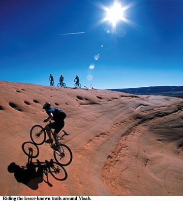
(Published March, 2002, Utah Outdoors magazine)
Editor’s note: In seven years as a Moab resident, Marshall Hannum took the time to get lost in the crenelated landscape as often as possible. He says he found his best moments while working his way out of the labyrinth of rock, sand and water. We asked him to describe some of his favorite lesser-known mountain bike rides, which are great starting points if you’re trying to get good and lost. "I won’t tell anyone the real unknown secrets because, the truth is, you’ll find them if you go looking," Hannum said. "A great place to get started is the Top of the World Trail. On the map I use it is the only place in all of Canyonlands with an official killer viewpoint."
Little Canyon Rim
This is a variation of the old standby Gemini Bridges trail. Beginning from the parking lot eight miles north of Moab on Hwy. 191, this trail follows the same route as Gemini but at the spur into Arths Pasture you want to shoot off to the north to overlook the Island in the Sky Road. The trail then wraps east and climbs to the top of a massive slickrock precipice overlooking Arches to the east. The fun starts here. After a break to choke down a Powerbar and catch the view at the overlook, the ride turns to the west and descends through a maze of slickrock canyons and plazas. Be watchful for the kerns or you may end up “dry gulched” and have to retrace your steps. The descent brings you back to the main Gemini Bridges Road and you rejoin the hordes feeling a little smug in the knowledge that they have no clue about the great terrain they just rode past.
Onion Creek
This is a great “family ride” even on the hottest of Moab summer days. The trailhead is about 20 miles from Moab going east on Hwy. 128, the “River Road.” The sign to look for says “Fisher Valley Ranch.” Parking is about one mile off the highway. The directions are simple: Get on your bike and ride up the road. The surface is graded single-lane two track. The road ascends a canyon that becomes narrow with convoluted, near-vertical walls. It is hard to keep your eyes on the trail since they tend to pick out strange animal shapes or hoodoos and goblins, depending on your orientation. The reason for the name of this trail becomes quickly apparent as the creek meanders across its path no less than 27 times before the final steep climb to Fisher Valley Ranch.
There is a feeling that you may have just found a little piece of paradise when you reach the hanging valley that contains this quaint single-family ranch with its lush irrigated fields. Here cows lazily chomp and wonder what these strange creatures are doing rolling through their peaceful home.
The valley is bounded by red rock formations and the Fisher Towers to the north and the foothills of the La Sals on the south. Once you finally decide that it is time to leave this place you are faced with an immensely pleasurable descent. Rolling downhill on a well-graded road you splash through the stream crossings. The sensation is contagious and soon your whole party will be frolicking like kids in a puddle. Your car will be a total mess by the time you transport the filthy bikes and bikers back to town.
Top of the World
Beginning at the Entrada Bluffs Road, which takes off from Dewey Bridge on Hwy. 128, this ride offers a most spectacular viewpoint in a place where that is a very tall claim. The ride resembles a geometry lesson that I vaguely remember from high school. It is the asymmetrical curve (or something like that) of bike rides. The concept is that the curve begins on the horizontal axis (flat ground) and becomes very steep. It comes continuously closer to the vertical axis without actually ever becoming vertical. The ride starts out like an easy stroll but the last mile is a bike push for all but the most fanatical granny gear pushing masochist. The real reward is at the top where the nearly psychedelic view of Fisher Towers is enhanced by the lack of oxygen in the brain. Watch out on the way down. A bicycle can easily get out of control without a large dose of caution. It is like riding a bull in a rodeo for the first mile or so until the grade and terrain mellow out.
Courthouse Wash
This route follows the Monitor and Merrimac Trail (a seemingly benign route that soon turns into a sand bog long enough to ruin a good marriage). Leave that trail by taking a left before the entrance to the canyon marked with a sign saying “Monitor and Merrimac Trail.” Ascend the canyon rim parallel to Highway 191 heading south until it dead-ends at the top of a monolithic dome overlooking Hwy. 313 as it enters Island in the Sky. From here you can see part of the Little Canyon Rim trail described above as it crosses a small valley. You can now make any of a number of circuitous descents that need to be marked more clearly. The thing to keep in mind is to stay on one of the many single or double tracks that have been well established and point your bike in the direction of the gap between the two huge slickrock domes to the north. Upon reaching the gap you have the choice of taking a direct route on the Jeep trail back to the car or looking around a bit for the legendary slickrock halfpipe that is rideable for nearly half a mile with some creative route finding. I wouldn’t advise the halfpipe unless you have someone to guide you or you are prepared to spend the late afternoon backtracking and trying to beat the sun back to your car.