By Dave Webb 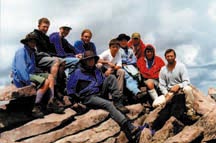
Quick Find: Fishing Opportunities Approaches To Kings Peak Hints For Backpackers
High Uintas Garfield Basin Map
Why Hike Kings Peak
- Because it's the highest mountain in Utah - 13,528 feet above sea level.
- Because the scenery is spectacular.
- Because it's a long, challenging hike that provides an incredible sense of accomplishment.
- Because there are wonderful fishing opportunities along the way.
- Because it's an experience I wanted my kids to have.
When I close my eyes I see Boy Scouts wearing brightly colored plastic ponchos, carrying full backpacks, trudging through mud puddles on a forest trail in the Uinta Mountains.
I recently hiked to Kings Peak with Varsity Scouts from Troop 2, Salt Lake City. Five days on the trail. Heavy rain five days in a row. Heavy rain three of the four nights we were in the mountains. Five days hiking through dense forest, across flower-filled meadows and over passes above the tree-line. All for the privilege of scrambling up the barren, rocky face of Utah's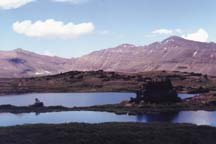
highest mountain - which towers 13,528 feet above sea level. It was as great trip!
Rain, hard hail and a few snowflakes. Typical summer weather in the Uintas. No, summer is the wrong word. Summer doesn't exist in the High Uintas. Spring and fall blend together and last from mid-July through August. The rest of the time it's winter in the mountains.
We started our trek on July 28 and reached the summit on July 30. We crossed snowfields which would have been impassible a couple weeks earlier in the season.
We approached the peak from the south, starting at the Long Park trailhead above Hell Canyon 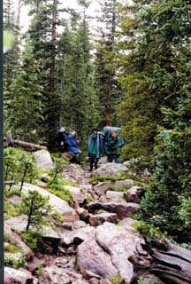 in the Yellowstone River drainage. We hiked 11miles the first day, through Swasey Hole and up into Garfield Basin, where we camped at Spider Lake. The hike wore us out - 11 miles with full packs over a rough, steep trail is about the maximum distance for normal people.
On day two we camped above tree line at Lake Y-19, just over Tungsten Pass. We hiked only 5.5 miles that day, taking time to fish and rest up for the intense challenge that would come on day three, when we challenged the summit. (The fishing was good at Y-19 - lots of pan-sized brookies and a few nice-sized fish.)
The next morning we gulped down a quick breakfast and hit the trail, leaving our backpacks in camp. Up to the top of Anderson Pass and then up the rocky face of the peak.
Eight hours later we were back at camp, exhausted but thrilled by the adventure of standing on top of the world - at least the top of our world. The view from the top of Kings is truly incredible. To the south you can see down the Yellowstone River and over the Garfield Basin area, with its many beautiful lakes. To the north you can see the Henry's Fork drainage - with a cluster of pretty lakes near the head of the drainage - then down into Wyoming. To the east you look across the Painter Basin and out across part of the Uinta River Drainage.
The Uintas include some of the prettiest mountains, forests and lakes to be found anywhere, and you can see the best of them from the top of Kings.
The trail from Garfield Basin is one of the more difficult ways to approach Kings Peak. Why did we choose it? Two reasons: First, there is more fishing opportunity in a wide variety of lakes and streams, and second, we needed a long trek to help the Scouts earn their hiking merit badge. All in all the kids hiked about 50 miles.
The most popular fishing lakes along the trail are Five Point, Gem, Swasey, X-59 and Spider. They all provide campsites, horse fed and good fishing. Of course, fishing in the Uintas is sometimes spotty. It can be very good one minute and dead the next. In general, if fishing isn't good at one lake it will probably be good at the next.
Brook trout reproduce well in Bluebell, Doll, Gem and Y-31. These lakes usually provide fast fishing for smaller fish. They are great for Scouts and others who want to build fishing skills.
We caught fish in every lake and stream we tried, with the exception of Y-20. We're told that lake has some grayling but we saw no evidence of fish live.
There are many ponds and tiny lakes in the area. Some support fish populations. If the pond has spots deep enough that you can't see the bottom, and if there is a good flow of water coming in or going out, then it's probably worth a try.
Small spinners and small, dark flies work well in the Uintas. Mepps, Panther Martins, Roostertails and Spin-A-Lures are good choices. Renegade, mosquito, gnat, ant and attractor patterns are good choices for fly fishers.
The streams almost always provide fast fishing for small fish, but are virtually overlooked. Everyone wants to camp near a lake and everyone fishes the lakes. The Yellowstone River and Garfield Creek both provide miles of fishing opportunity. They are particularly fun to fish in the high meadows where the flows are slower.
Approaches To Kings Peak
Distances are approximate, and are one-way.
- Long Park Trailhead to Gilbert Basin to Anderson Pass to Kings Peak - 17 miles. Difficult. Little elevation gain but lots of ups and downs into basins and over ridges and passes. Long Park is 10,100 feet above sea level. Horses are common on this trail but the going is rough. Lots of rocky spots and some deadfall.
- Swift Creek Trailhead to Gilbert Basin to Anderson Pass to Kings - 17 miles. A difficult, steep trail with several river crossings which require wading through swift water. This is the best trail to get horses into Garfield Basin. The Swift Creek Trailhead is located at an elevation of 8,100 feet.
- Swift Creek Trailhead up the Yellowstone River to the Highline Trail to Anderson Pass and then to Kings. 18 1/2 miles. This is a more direct approach to the Peak. The trail offers relatively easy hiking all the way to the meadow below Anderson Pass. This is an easy trail for horses. Fishing is good in the river but you do not pass any lakes.
- Henry's Fork River Trailhead to Gunsight Pass to Anderson Pass to Kings. 14 1/2 miles. This is the easiest and shortest approach. The trail is fairly flat most of the way up the mountain, but becomes steep over Gunsight and Anderson passes. The stream and the scenic lakes in the upper basin offer good fishing.
- China Meadows Trailhead along Smith's Fork past the Red Castle lakes then across Smith's Fork Pass to the Highline Trail to Anderson Pass to Kings. 18 miles. The trail skirts around the Red Castle lakes - which are considered by many to be the most scenic in the Uintas. Plan extra time and miles if you choose to visit them. They are popular destinations.
- Many people like to hike across the Uintas from north to south, or vice-a-versa. Hike Henry's Fork to King's Peak, then down the Yellowstone.
Some people like to hike the mountains from east-to-west, along the 100-mile Highline Trail which crosses the Wilderness Area. The trail crosses Anderson Pass just under Kings. Trailheads are located on Highway 150 on the west and East Park Reservoir on the east. Side trails intersect the Highline at many locations, allowing backpackers to choose a trek long enough to suit their fancy.
Many groups horse-pack to a base camp near Anderson Pass, then day-hike to the peak. That approach takes much of the difficulty out of the trek. Outfitters often pack in gourmet food, comfortable cots and warm, heavy tents. The U-Bar Ranch (800-303-7256) on the Uinta River offers excellent horse-pack trips to the Kings Peak area, and to fishing destinations.
A backpack trip to Kings Peak requires careful planning and preparation. It does not make a good first backpack trip. Experienced backpackers who know the Uintas and know how to read a map can make the trip themselves. Those new to the sport should go with an experienced leader. Kids under age 14 will probably have trouble, and will not be able to carry their share of equipment.
Anyone can make it to the top if given enough time. However, when backpacking time complicates trips. The more days on the trail, the more food you have to carry. Five-to-six days are optimum. That allows some time to explore and to fish.
Most years the trail to Kings Peak is hikeable from late July through August. However, snow can close the high passes at any time. Watch the weather and be careful.
Lightening is the big killer on Kings Peak. If a thunderstorm threatens, head for lower country. If lightening flashes around you, jump into any depression you can find and sit it out.
Mornings are best for hiking Kings Peak. Thunderstorms most commonly develop in the afternoon. Plan to reach the summit by noon. Camp within six miles of the peak and get an early start.
Hypothermia is also a real danger. When the sun shines it will feel warm and you will sunburn quickly. But if a breeze comes up or clouds push across the sun the temperature will fall rapidly. Wet clothing in a breeze can lower your body temperature to a dangerous level very quickly. Always carry a poncho and jacket. Carry matches so you can build a fire. (There is no wood on the face of Kings Peak - you will have to head to lower ground.) Plan warm meals. Nothing feels better than warm soup after you've been chilled by a cold Uinta Mountain wind.
Boots - You need stout hiking boots that allow you to tromp on sharp rocks all day without discomfort. It's essential that your boots fit your feet. Boots should be snug but not too tight, allowing for padded socks. (Many hikers prefer to wear a pair of silky, thin socks next to their skin and then a pair of thick socks.) If your foot slides around in the boot it will produce a blister. Boots should be waterproof - when it rains the trails turn into streams. You will also need to wade through marshy meadows and rock-hop streams. Gortex is great. On our trip the people wearing Gortex boots had dry feet - everyone else got wet. Wet socks tend to clump, become uncomfortable and produce blisters.
Backpack - A good backpack will have padded shoulder straps, a padded waist belt and will be adjustable so it can be made to fit your body size. Inexperienced packers tend to rely on their shoulders to support the weight of the pack. You can carry a much heavier load more comfortably by using the waist belt properly, so that your hips carry much of the weight. Put on the pack then lean over and hitch it up so the weight is off your shoulders. Position the waist belt so it rides just above your hipbones, then pull it tight. Stand erect and loosen the shoulder straps until your hips are supporting much of the weight. Most packs allow you to tighten and loosen the shoulder straps while you hike, allowing you to experiment to find the most comfortable position and to make adjustments to compensate for tired or sore muscles.
Poncho - Plan on rain every day. You need a jacket and you also need a poncho. Most ponchos are roomy enough they can cover you and most of your pack, helping to keep your equipment dry. Even then, you need to pack your sleeping bag and clothing in waterproof bags inside your back. Nothing is worse than sleeping in a wet sleeping bag in the mountains where temperatures in August often fall into the 30s.
Tent - Make sure your tent is in good condition - that it doesn't leak. If you arrive at your destination without your tent poles you are in trouble.
Water filter - Water is plentiful in the Uintas. But most lakes and streams are contaminated with Giardia and you will get very sick a few days after drinking unfiltered water. You can boil the water, or add harsh chemicals, but filters are easier and produce water that tastes better. Springs are abundant and consistent, but storms often make them muddy. If you find a real spring - where water comes out of the ground for the first time - it is probably safe to drink. But springs can be tricky. In some spots water bubbles out, flows for a few yards, then goes under rocks and comes out again a little further down the hill. It's better to be safe and filter all your water.